Last updated: June 3, 2026
Quick Answer
Higgsfield AI’s Earth visualization technology uses advanced machine learning models to transform raw geospatial data into interactive, high-fidelity 3D representations of the planet. Unlike traditional mapping tools that stitch together static satellite photos, this system generates dynamic, AI-enhanced visual models that can simulate environmental changes, overlay real-time data streams, and render terrain at resolutions previously unavailable outside classified military systems. The technology is aimed at researchers, urban planners, climate scientists, and enterprises that need more than flat maps can offer.
Key Takeaways
- Higgsfield AI combines neural radiance fields (NeRFs) and diffusion models to create photorealistic 3D Earth visualizations from multi-source data.
- The platform differs from Google Earth by generating novel viewpoints and predictive simulations rather than displaying pre-captured imagery.
- Primary users include climate researchers, urban planners, defense analysts, and logistics companies.
- Data resolution can reach sub-meter accuracy when paired with high-quality source imagery, though results vary by region.
- Privacy safeguards include automated blurring of identifiable individuals and vehicles, along with restricted-zone masking.
- The system requires a modern GPU (NVIDIA RTX 4070 or equivalent minimum) for local rendering, though cloud-based access lowers the hardware barrier.
- Pricing follows a tiered SaaS model, with research licenses reportedly starting around $500/month (estimate based on industry comparisons; Higgsfield has not published a public price list as of mid-2026).
- The technology is not a replacement for real-time satellite monitoring or GPS navigation tools.
What Exactly Does Higgsfield AI’s Earth Visualization Tech Do?
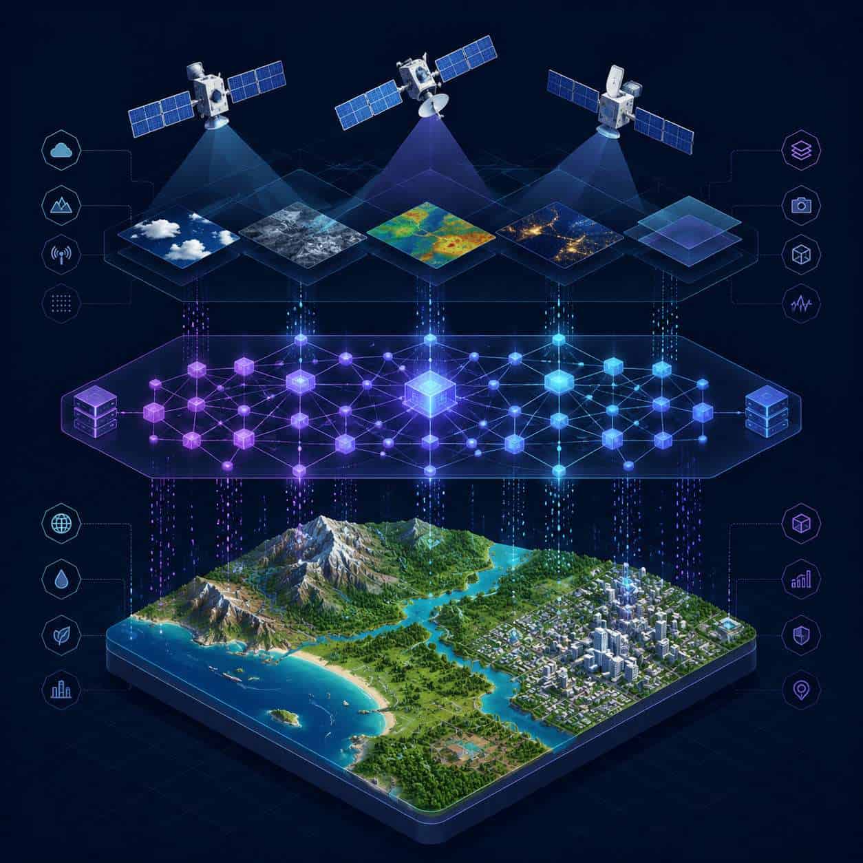
Higgsfield AI’s platform ingests satellite imagery, aerial photography, LiDAR point clouds, and sensor data, then uses AI models to build continuous 3D representations of geographic areas. The output is not a static image; it is an interactive, explorable environment.
The core technical approach relies on neural radiance fields, a method that learns how light interacts with surfaces from multiple 2D images and then synthesizes new 3D views from any angle. Higgsfield extends this with:
- Temporal modeling: The system can show how a landscape looked at different points in time and project forward based on trend data.
- Multi-layer data fusion: Users can overlay atmospheric data, ocean temperature readings, vegetation indices, and infrastructure maps onto the same 3D model.
- Generative gap-filling: Where satellite coverage is incomplete (due to cloud cover or sensor gaps), the AI fills in missing areas using learned patterns from similar terrain.
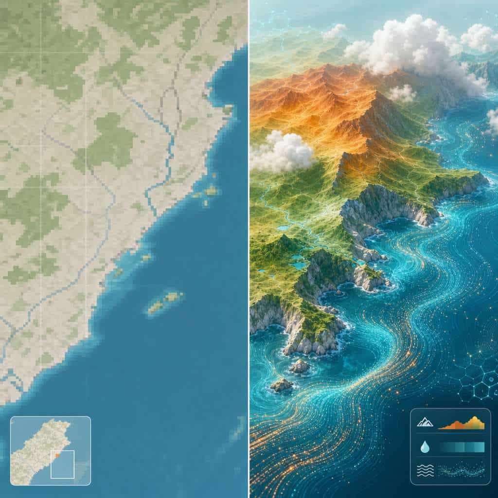
This is the foundation of what makes revolutionizing global perspectives through Higgsfield AI’s approach distinct. Instead of showing you what a camera captured, it builds a model of what the world actually looks like and how it behaves.
For those exploring other AI-driven tools reshaping how we interact with technology, our guide to discovering AI platforms covers dozens of notable examples.
How Is This Different from Google Earth or Other Mapping Tools?
Google Earth displays stitched-together satellite photographs. Higgsfield AI generates a learned 3D model that can produce views, simulations, and predictions that no camera ever captured.
Here’s a concrete comparison:
| Feature | Google Earth | Higgsfield AI Platform |
|---|---|---|
| Data source | Satellite/aerial photos | Satellite, LiDAR, sensor fusion + AI generation |
| 3D rendering | Photogrammetry (photo-based mesh) | Neural radiance fields + diffusion models |
| Temporal views | Historical imagery (snapshots) | Continuous temporal interpolation + forecasting |
| Data overlays | Limited (weather, some layers) | Extensive (climate, infrastructure, custom datasets) |
| Gap handling | Shows cloud cover or blank spots | AI-generated fill based on learned terrain patterns |
| Interactivity | Pan, zoom, Street View | Full 3D exploration, simulation, scenario modeling |
| Primary audience | General public | Researchers, enterprises, government agencies |
The key distinction: Google Earth is a viewer. Higgsfield AI is a modeling and simulation environment. If you need to see what a neighborhood looks like from above, Google Earth works fine. If you need to model how sea level rise will affect that neighborhood over 20 years, Higgsfield is built for that.
How Does the AI Process and Render Global Geographic Information?
The rendering pipeline has four main stages: data ingestion, feature extraction, model training, and real-time rendering.
- Data ingestion — Raw data from satellites (optical and radar), drones, LiDAR scanners, and IoT sensors is collected and georeferenced.
- Feature extraction — Convolutional neural networks identify terrain types, structures, vegetation, water bodies, and atmospheric conditions.
- Model training — Neural radiance fields learn the volumetric representation of each geographic area. For large regions, the system uses a tiled approach, training smaller models that are then stitched into a global mesh.
- Real-time rendering — Users interact with the model through a client application that sends view requests to either a local GPU or cloud rendering servers. The system returns photorealistic frames at interactive speeds.
This pipeline is compute-intensive. Training a regional model can take days on a cluster of GPUs. But once trained, the model can be explored in real time, which is where the practical value lives.
If you’re interested in how AI development tools are evolving more broadly, our deep dive into open-source language model notebooks provides useful context.
How Does Higgsfield AI’s Approach Differ from Satellite Imaging?
Traditional satellite imaging captures light reflected from the Earth’s surface at a specific moment. Higgsfield AI’s approach treats satellite images as training data, not as the final product.
The AI learns the underlying 3D structure and material properties of terrain from many satellite passes. It can then:
- Render the scene from angles no satellite ever photographed
- Remove temporary obstructions like clouds or smoke
- Simulate lighting conditions at any time of day or season
- Blend data from different sensor types (optical, infrared, radar) into a unified visual model
Think of satellite imaging as taking a photograph. Higgsfield’s method is closer to building a detailed scale model of the location and then photographing that model from any angle you choose.
What Industries Could Benefit Most from This Technology?
The technology is most valuable for industries that make high-stakes decisions based on geographic and environmental data.
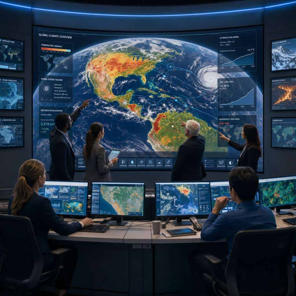
- Climate science and environmental monitoring: Tracking deforestation, glacier retreat, coral reef health, and urban heat islands over time.
- Urban planning and civil engineering: Simulating infrastructure projects, flood risk modeling, and zoning analysis.
- Defense and intelligence: Terrain analysis, mission planning, and change detection in areas of interest.
- Insurance and risk assessment: Evaluating property exposure to natural disasters with more accurate terrain models.
- Agriculture: Precision farming through detailed terrain and soil moisture modeling.
- Energy: Site selection for wind farms, solar installations, and pipeline routing.
- Logistics and supply chain: Route optimization using detailed terrain data that accounts for seasonal changes.
Companies already using AI-powered workflow tools for automation will find that geospatial AI fits naturally into data-driven decision pipelines.
Is This Technology Useful for Climate Scientists and Researchers?
Yes, and climate research is arguably the strongest use case. The platform’s ability to model temporal changes and overlay multi-source environmental data makes it a powerful research tool.
Climate scientists can use Higgsfield AI to:
- Visualize ice sheet volume changes over decades using historical satellite archives
- Model coastal erosion scenarios under different sea level rise projections
- Track deforestation rates with higher accuracy than periodic satellite snapshots allow
- Combine atmospheric sensor data with surface observations for integrated climate models
Common mistake: Assuming the AI’s predictive visualizations are forecasts. They are scenario models, not weather predictions. The system shows “what would this area look like if X trend continues,” not “this will happen.” Researchers need to treat outputs as modeling tools, not oracles.
What Kind of Data Resolution and Accuracy Can Higgsfield AI Provide?
When fed high-quality source data (commercial satellite imagery at 30 cm resolution or better, plus LiDAR), the system can produce 3D models with sub-meter spatial accuracy. In areas with only public satellite data (such as Sentinel-2 at 10 m resolution), the output is correspondingly coarser.
Key accuracy factors:
- Source data quality: Higher resolution inputs produce better models. The AI can enhance resolution somewhat, but it cannot invent detail that isn’t implied by the training data.
- Temporal coverage: More satellite passes over the same area improve the 3D reconstruction.
- Terrain type: Urban areas with sharp geometric structures tend to reconstruct well. Dense forest canopies and underwater terrain are harder.
- Validation: Higgsfield reports internal testing against ground-truth LiDAR surveys, but independent third-party accuracy benchmarks are limited as of mid-2026.
Are There Privacy Concerns with This Level of Earth Visualization?
Any technology that renders detailed views of the Earth’s surface raises legitimate privacy questions. Higgsfield AI addresses this through several mechanisms, but concerns remain.
Built-in safeguards:
- Automated detection and blurring of faces, license plates, and identifiable personal features
- Restricted-zone masking for sensitive government and military facilities
- Data retention policies that limit how long raw source imagery is stored
Remaining concerns:
- The AI’s gap-filling capability could theoretically generate plausible but fabricated details of private property
- Temporal modeling could reveal patterns of activity (construction, vehicle movement) even when individual frames are anonymized
- Regulatory frameworks for AI-generated geospatial imagery are still developing in most jurisdictions
Choose this platform if you operate under clear data governance policies and need high-fidelity terrain modeling. Avoid it if your use case involves surveilling individuals or if you lack the legal framework to handle geospatial data responsibly.
What Computer Specs Do You Need to Run Higgsfield AI’s Platform?
For cloud-based access, a modern web browser and stable internet connection (minimum 50 Mbps recommended) are sufficient. For local rendering and model training, the requirements are significantly higher.
| Component | Minimum | Recommended |
|---|---|---|
| GPU | NVIDIA RTX 4070 (12 GB VRAM) | NVIDIA RTX 4090 or A6000 (24+ GB VRAM) |
| CPU | 8-core modern processor | 16-core or higher |
| RAM | 32 GB | 64 GB or more |
| Storage | 1 TB NVMe SSD | 2+ TB NVMe SSD |
| Network | 50 Mbps | 200+ Mbps for streaming large datasets |
Most users will access the platform through cloud rendering, which shifts the hardware burden to Higgsfield’s servers. Local installations are primarily for organizations with data sovereignty requirements or classified workloads.
For developers exploring AI-powered tools that also demand capable hardware, our overview of Cursor AI as a next-generation IDE discusses similar system requirements.
How Much Does Higgsfield AI’s Visualization Technology Cost?
Higgsfield AI has not published a public pricing page as of June 2026. Based on industry comparisons with similar enterprise geospatial AI platforms (such as Maxar’s Precision3D and Planet Labs’ analytics tier), pricing likely follows a tiered SaaS model.
Estimated pricing structure (based on comparable platforms, not confirmed by Higgsfield):
- Research/academic tier: $500-$1,500/month with limited compute credits
- Professional tier: $3,000-$10,000/month with expanded data access and rendering capacity
- Enterprise/government contracts: Custom pricing, likely six figures annually for large-scale deployments
These are estimates. If cost is a primary concern, contact Higgsfield directly for a quote. Academic institutions may qualify for discounted or sponsored access through research partnership programs.
What Are the Technical Limitations of Their Earth Visualization System?
No technology is without constraints. Higgsfield AI’s system has several known limitations:
- Real-time data lag: The platform does not provide live satellite feeds. Data freshness depends on the most recent satellite pass, which can range from hours to weeks.
- Ocean and underwater terrain: Sub-surface modeling is limited to bathymetric data sources, which are far sparser than land-based imagery.
- Dense vegetation: Forest canopy penetration is only possible with LiDAR or radar data, not optical imagery alone.
- Computational cost: Training new regional models requires significant GPU time, making rapid deployment to previously unmodeled areas slow.
- AI hallucination risk: The generative gap-filling feature can produce plausible but inaccurate terrain details where source data is thin. Users must verify critical outputs against ground truth.
Who Shouldn’t Use This Technology?
This platform is not for everyone. You likely don’t need Higgsfield AI if:
- You need real-time navigation — use GPS and standard mapping apps instead.
- You want casual exploration of the planet — Google Earth is free and sufficient.
- Your work involves indoor spaces — this is an outdoor geospatial tool.
- You need sub-centimeter precision for construction or surveying — traditional survey equipment remains more accurate.
- Your budget is under $500/month and you don’t qualify for academic pricing.
The technology serves professionals who need dynamic, data-rich 3D models of the Earth’s surface for analysis and decision-making. If your needs are simpler, simpler tools will serve you better and cost less.
What Are Common Misunderstandings About Global Visualization Tech?
Several misconceptions circulate about AI-powered Earth visualization, and it’s worth addressing them directly.
“It’s just Google Earth with better graphics.” No. The underlying technology is fundamentally different. Google Earth composites photographs. Higgsfield AI builds learned 3D models that support simulation and prediction.
“AI-generated views are as reliable as photographs.” They are not. AI-generated views are model outputs that approximate reality. They should be validated against ground truth for any critical application.
“This technology can see through walls or underground.” It cannot. The system works with surface-level and near-surface data. Underground visualization requires separate geophysical survey data.
“Higher resolution always means better results.” Not necessarily. Resolution matters, but temporal coverage, sensor diversity, and data quality all affect output accuracy as much as pixel count.
For a broader look at how AI tools are being applied across different domains, check out our roundup of AI websites worth bookmarking.
Conclusion
Revolutionizing global perspectives through Higgsfield AI’s Earth visualization technology represents a meaningful shift in how we model and understand our planet. The platform moves beyond static satellite photography into dynamic, AI-generated 3D environments that support analysis, simulation, and scenario planning.
Actionable next steps if you’re considering this technology:
- Assess your actual need. If you need dynamic terrain modeling, temporal analysis, or multi-layer data visualization, this platform is worth evaluating. If you need basic mapping, free tools will suffice.
- Request a demo. Contact Higgsfield AI directly to see the platform in action with data relevant to your industry.
- Evaluate your data sources. The system’s output quality depends heavily on input data. Determine whether you have access to (or budget for) high-resolution satellite imagery and supplementary sensor data.
- Plan for validation. Build ground-truth verification into your workflow, especially for any AI-generated gap-filled areas.
- Review privacy and compliance requirements. Ensure your organization’s data governance policies cover AI-generated geospatial content.
The technology is still maturing, and independent benchmarks are limited. But for organizations that work with geographic data at scale, Higgsfield AI offers capabilities that traditional mapping tools simply cannot match. If you’re building AI-driven workflows in other areas of your organization, tools like n8n for workflow automation and AI-powered content generation can complement geospatial analysis within a broader data strategy.
Related Higgsfield guides: explore Higgsfield Earth Zoom technology and the Higgsfield AI app deep dive.
Frequently Asked Questions
What is Higgsfield AI’s Earth visualization technology? It is an AI platform that transforms satellite imagery, LiDAR, and sensor data into interactive 3D models of the Earth’s surface using neural radiance fields and machine learning.
Can I use it for free? No free tier has been announced as of June 2026. Academic researchers may qualify for discounted access through partnership programs.
Does it work in real time? The visualization is interactive in real time, but the underlying data is not live. There is a lag between satellite capture and model availability.
Is it more accurate than Google Earth? For 3D terrain modeling and data overlay, yes. For simple overhead photography of a specific address, Google Earth may be more current and is certainly more accessible.
Can it predict natural disasters? It can model scenarios (such as flood zones under different rainfall conditions), but it does not predict when or where disasters will occur.
What data formats does it accept? The platform supports standard geospatial formats including GeoTIFF, LAS/LAZ (LiDAR), shapefiles, and common satellite data formats like SAFE and HDF5.
Is the technology available worldwide? Coverage depends on available source data. Well-imaged regions (North America, Europe, East Asia) have better model quality than remote or conflict-affected areas.
How often are the models updated? Update frequency depends on satellite revisit rates and the user’s data subscription. Some areas update weekly; others may lag by months.
Can I export models for use in other software? Yes. Higgsfield AI supports export to standard 3D formats (OBJ, glTF) and GIS-compatible formats for integration with tools like QGIS and ArcGIS.
Does it require programming knowledge? The standard interface is GUI-based and does not require coding. An API is available for developers who want to integrate the platform into custom workflows.
References
- Mildenhall, B. et al. (2020). “NeRF: Representing Scenes as Neural Radiance Fields for View Synthesis.” European Conference on Computer Vision.
- Planet Labs (2024). “Planet Analytic Feeds: Technical Specifications.” planet.com
- Maxar Technologies (2025). “Precision3D Registration Product Guide.” maxar.com
- European Space Agency (2023). “Sentinel-2 Mission Overview.” esa.int
Useful Resources: Higgsfield AI official platform & AI industry news on TechCrunch