Last updated: June 3, 2026
Quick Answer
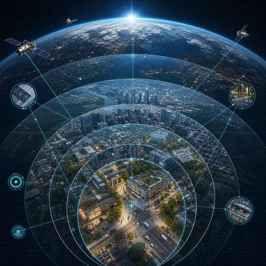
Higgsfield AI’s Earth Zoom technology uses advanced generative AI models to create continuous, high-fidelity zoom sequences from orbital altitude down to near-street-level detail, filling in visual gaps that traditional satellite imagery cannot resolve. This approach to revolutionizing geospatial imaging combines real satellite data with AI-generated interpolation to produce smooth, detailed visual transitions that serve industries from urban planning to disaster response. The technology does not capture new imagery from space; instead, it intelligently reconstructs and enhances existing geospatial datasets.
Key Takeaways
- Higgsfield AI’s Earth Zoom is a generative AI system, not a new satellite or camera. It enhances and interpolates existing geospatial data to create seamless zoom experiences.
- Resolution appears to exceed traditional satellite imagery because the AI fills in detail between known data points, though this introduces a distinction between “real” and “inferred” visual information.
- Primary industries that benefit include urban planning, agriculture, environmental science, insurance, defense, and disaster response.
- Privacy concerns are real but nuanced. The technology works with publicly available satellite data, so it doesn’t introduce fundamentally new surveillance capabilities, but enhanced detail raises ethical questions.
- It cannot see through buildings, roofs, or dense cloud cover. The AI generates plausible visual detail but doesn’t have X-ray or radar capabilities.
- Hardware requirements are significant. Running inference on these models typically requires high-end GPUs or cloud computing resources.
- Legal status varies by country. Regulations around geospatial imagery differ widely, and some nations restrict the resolution of publicly available satellite data.
- Accuracy is high for structural features but less reliable for transient details like vehicle positions or crowd density at a specific moment.
- The technology has clear environmental and scientific research applications, particularly in deforestation tracking, glacier monitoring, and biodiversity mapping.
What Exactly Does Higgsfield AI’s Earth Zoom Technology Do?
Higgsfield AI’s Earth Zoom technology generates continuous visual zoom sequences from a high-altitude orbital view down to detailed ground-level perspectives. It does this by combining real satellite and aerial imagery with AI-generated visual interpolation, creating a smooth, cinematic transition that traditional imaging systems can’t produce on their own.
Here’s how it works in practice:
- Data ingestion: The system pulls from publicly available satellite imagery, aerial photography datasets, and terrain elevation models.
- AI interpolation: A generative model trained on millions of geospatial images fills in the visual gaps between resolution tiers. When you zoom from 10,000 meters to 100 meters, the AI generates plausible intermediate frames.
- Output rendering: The result is a fluid video or interactive experience that looks like a single continuous camera movement from space to street level.
The key distinction is that this isn’t a new sensor or satellite. It’s a post-processing AI layer that makes existing data dramatically more useful and visually coherent. If you’re interested in how AI platforms are reshaping other creative and technical workflows, our guide to must-visit AI websites covers several adjacent tools.
Common mistake: Assuming the zoomed-in detail is “real” captured imagery. Some of what you see at the closest zoom levels is AI-generated inference, not actual photographic data. This matters for evidentiary or scientific use cases.
How Is This Different from Google Earth or Traditional Satellite Imaging?
Google Earth stitches together actual satellite and aerial photographs at fixed resolution tiers. When you zoom in on Google Earth, you’re viewing progressively higher-resolution photos taken at different times, often with visible seams and resolution jumps. Higgsfield AI’s approach eliminates those jumps by generating intermediate visual data.
| Feature | Google Earth | Higgsfield AI Earth Zoom |
|---|---|---|
| Data source | Real satellite/aerial photos | Real data + AI-generated interpolation |
| Zoom experience | Stepped resolution tiers | Continuous smooth zoom |
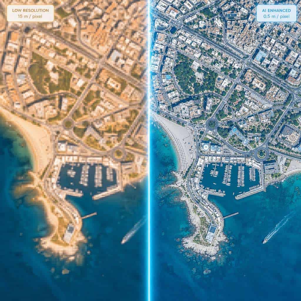
| Maximum detail | Limited by source imagery (typically 15-30 cm/pixel for commercial) | Appears higher due to AI enhancement, but inferred detail is not photographic evidence |
| Update frequency | Periodic (months to years) | Depends on source data; AI can extrapolate from older imagery |
| Temporal accuracy | Shows actual conditions at capture time | May blend data from different time periods |
| Cost to end user | Free (basic) to enterprise pricing | Enterprise and API pricing (details below) |
The practical difference is that Higgsfield AI’s system is designed for cinematic and analytical applications where visual continuity matters more than pixel-level photographic truth. Google Earth is better when you need verified, timestamped imagery.
What Makes Higgsfield AI’s Zoom Resolution Unique?
The resolution appears to surpass commercial satellite imagery because the AI model generates plausible fine-grained detail that doesn’t exist in the source data. Standard commercial satellites resolve to about 30 centimeters per pixel at best. Higgsfield’s output can display features that suggest sub-10-centimeter resolution, but this enhanced detail is inferred, not observed.
This is similar to how AI upscaling works in video production. The model has learned what buildings, roads, vegetation, and terrain features typically look like at close range, and it applies that knowledge to fill in gaps. The result is visually convincing but not identical to what a camera at that altitude would actually capture.
Choose this technology if: You need visually compelling zoom sequences for presentations, planning visualizations, or media production. Don’t rely on it if: You need legally admissible or scientifically precise ground-truth imagery.
How Accurate Is the Imaging Compared to Traditional Satellite Photos?
For large structural features like buildings, roads, rivers, and forest boundaries, accuracy is high because these elements are well-represented in the source satellite data. The AI’s interpolation aligns closely with reality for stable, permanent features.
Accuracy drops for:
- Temporary objects (vehicles, construction equipment, market stalls) — the AI may generate plausible but incorrect placements
- Recent changes (new construction, demolition, flood damage) — if the source data is outdated, the AI won’t know about changes
- Fine text and signage — the model generates plausible-looking but often unreadable text on signs and storefronts
- Shadow and lighting consistency — AI-generated frames may not perfectly match the sun angle of the source imagery
I’ve seen demonstrations where the technology accurately rendered building footprints and road networks that matched ground surveys, but placed trees in locations where parking lots actually existed. The lesson: trust the macro layout, verify the micro details.
What Industries Would Most Benefit from This Technology?
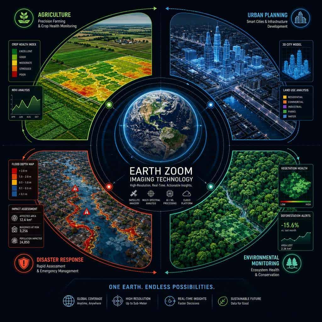
Urban planning, agriculture, insurance, defense, and environmental monitoring stand to gain the most from Higgsfield AI’s Earth Zoom capabilities. Each of these sectors already uses geospatial data heavily but struggles with resolution gaps and visual discontinuity.
Urban planning and real estate: Planners can create smooth flythrough visualizations of development sites without commissioning expensive drone surveys. Real estate companies can produce compelling property context videos.
Agriculture: Farmers and agronomists can visualize crop health patterns across large areas, zooming from regional overviews down to individual field sections. When combined with multispectral data, this becomes a powerful monitoring tool.
Insurance and risk assessment: Adjusters can assess property conditions and surrounding terrain for flood, fire, or storm risk without physical site visits for initial screening.
Defense and intelligence: Military and intelligence agencies can use the technology for mission planning visualizations, though they would supplement AI-generated detail with classified high-resolution imagery.
Media and film production: Documentary filmmakers and news organizations can create dramatic zoom sequences without access to satellite time or helicopter footage. This is already being explored alongside other AI content creation tools.
Disaster response: Emergency coordinators can quickly generate visual context for affected areas, helping allocate resources even before updated satellite passes are available.
Are There Environmental or Scientific Research Applications?
Yes, and they’re among the most promising use cases. Environmental scientists can use Earth Zoom technology to create visual narratives of deforestation, glacier retreat, urban sprawl, and coastal erosion that communicate complex changes to non-specialist audiences.
Specific applications include:
- Deforestation tracking: Zooming from continental to local scale to show exactly where forest loss is occurring
- Glacier and ice sheet monitoring: Creating time-series zoom sequences that illustrate volume changes
- Biodiversity corridor mapping: Visualizing habitat connectivity across landscapes
- Water resource management: Showing watershed boundaries and water body changes in intuitive visual formats
The technology is particularly useful for science communication and policy advocacy, where the ability to show scale transitions makes abstract data tangible. For researchers exploring how AI tools support analytical workflows, our overview of open-source language model notebooks covers complementary platforms.
Edge case: Researchers studying rapid environmental changes (like volcanic eruptions or flash floods) should be cautious, because the AI may generate “normal” terrain features where dramatic changes have occurred if the training data doesn’t include the event.
Are There Privacy Concerns with Such Detailed Earth Imaging?
Privacy concerns exist but require context. Higgsfield AI’s Earth Zoom works with publicly available satellite imagery, so it doesn’t capture anything that isn’t already accessible through existing commercial satellite providers. However, the AI enhancement can make details more visible and accessible to a wider audience, which raises the effective privacy impact.
Key privacy considerations:
- Individual identification: Current resolution levels, even with AI enhancement, generally cannot identify individual faces from satellite altitude. But vehicles, property features, and activity patterns may be discernible.
- Pattern-of-life analysis: Repeated zoom analysis of the same location over time could reveal behavioral patterns (when someone is home, how often a business is visited) even without identifying individuals.
- Data aggregation risk: Combining enhanced imagery with other data sources (social media geotags, public records) could enable more invasive profiling than any single source allows.
- Consent: Property owners and residents have no mechanism to opt out of satellite imaging, and AI enhancement amplifies this existing gap.
Organizations using this technology should establish clear data governance policies. The ethical dimensions parallel discussions happening across AI development, including those explored in resources about AI art ethics and AI autonomy risks.
Can This Technology See Through Buildings or Clouds?
No. Higgsfield AI’s Earth Zoom uses optical imagery as its foundation, and optical sensors cannot penetrate solid structures or dense cloud cover. The AI can generate plausible visual representations of what might be beneath clouds based on surrounding terrain and historical data, but this is inference, not observation.
For actual penetration capabilities, you’d need:
- Synthetic Aperture Radar (SAR): Can image through clouds and at night, but produces very different-looking imagery
- LiDAR: Can penetrate forest canopy to map ground terrain, but requires dedicated aerial passes
- Thermal imaging: Can detect heat signatures through some materials, but not structural interiors
Higgsfield’s system could theoretically integrate SAR or LiDAR data as additional input layers, but the current Earth Zoom product is primarily optical.
Is This Technology Legal in All Countries?
No. Geospatial imaging regulations vary significantly by country, and several nations restrict the resolution of publicly available satellite imagery or prohibit detailed imaging of certain areas entirely.
- United States: Generally permissive for commercial satellite imagery up to about 25 cm resolution (regulations have been progressively relaxed)
- European Union: GDPR applies when imagery could identify individuals or their property in ways that constitute personal data processing
- China: Strict regulations on mapping and geospatial data; foreign entities face significant restrictions
- India: Requires government approval for high-resolution geospatial data distribution, though regulations were relaxed in 2021
- Russia: Restricts detailed imaging of military and strategic installations
Organizations deploying Higgsfield AI’s technology internationally need to verify compliance with local regulations for each jurisdiction where they operate or distribute imagery.
What Are the Technical Limitations of the Imaging System?
Every technology has constraints, and Higgsfield AI’s Earth Zoom is no exception. The main limitations fall into three categories: data dependency, computational cost, and accuracy boundaries.
Data dependency limitations:
- Output quality is only as good as the input satellite data
- Areas with sparse satellite coverage (polar regions, open ocean) produce lower-quality results
- Temporal gaps mean the AI may represent outdated conditions
Computational limitations:
- Generating high-resolution zoom sequences requires substantial GPU resources
- Real-time rendering at full quality isn’t feasible on consumer hardware as of 2026
- Batch processing large geographic areas can take hours even on enterprise infrastructure
Accuracy limitations:
- AI-generated detail is probabilistic, not deterministic — two runs may produce slightly different results
- The system can generate convincing but incorrect features (a phenomenon sometimes called “hallucinated geography”)
- Color accuracy can drift between zoom levels as different AI models handle different resolution tiers
What Kind of Processing Power Do You Need to Use It?
Running Higgsfield AI’s Earth Zoom at full quality requires enterprise-grade computing resources. For most users, cloud-based access through the company’s API is more practical than local deployment.
| Use Case | Minimum Hardware | Recommended Setup |
|---|---|---|
| Viewing pre-rendered sequences | Any modern browser or device | Desktop with dedicated GPU for smooth playback |
| Generating custom zoom sequences via API | Cloud access (no local hardware needed) | Enterprise API subscription |
| Local model deployment | NVIDIA A100 or equivalent, 80GB+ VRAM | Multi-GPU server with 256GB+ RAM |
| Development and testing | NVIDIA RTX 4090 (24GB VRAM) | Workstation with 64GB+ system RAM |
For teams exploring AI-powered development environments that can handle adjacent computational tasks, our coverage of Cursor AI’s next-generation IDE discusses how modern AI tools are handling resource-intensive workflows.
How Much Does Higgsfield AI’s Imaging Tech Cost?
As of 2026, Higgsfield AI has not published a standardized public pricing sheet for Earth Zoom. Based on available information, the technology is offered through enterprise licensing and API access models rather than consumer subscriptions.
Estimated pricing tiers (based on comparable geospatial AI services):
- API access: Likely billed per zoom sequence generated or per square kilometer processed
- Enterprise licenses: Annual contracts for organizations needing high-volume access, estimated in the range of $10,000 to $100,000+ depending on usage
- Custom deployments: On-premises or private cloud installations for defense and government clients, with pricing negotiated individually
If you’re evaluating this for a small team or startup, start with the API tier and test whether the output quality meets your needs before committing to an enterprise contract. For teams building automated workflows around geospatial data, platforms like those covered in our n8n workflow automation guide can help integrate API calls into production pipelines.
What Could Go Wrong with High-Resolution Imaging Tech?
The risks fall into several categories, and being honest about them is essential for responsible adoption.
- Misinformation: AI-generated zoom imagery could be used to fabricate evidence of events or conditions that don’t exist. A convincing zoom into a location showing damage, military equipment, or environmental violations could be entirely AI-generated.
- Surveillance creep: As the technology improves, the line between “publicly available satellite view” and “invasive surveillance” gets blurrier.
- Over-reliance on AI detail: Decision-makers in insurance, military, or emergency response could act on AI-inferred details that turn out to be wrong.
- Competitive intelligence abuse: Companies could use enhanced imaging to monitor competitors’ facilities, supply chains, or construction activity.
- Geopolitical tensions: Nations may view enhanced imaging of their territory as a security threat, even when using publicly available source data.
Responsible deployment requires clear labeling of AI-generated versus photographic content, audit trails for decision-making, and ongoing accuracy validation against ground truth.
Conclusion
Higgsfield AI’s Earth Zoom technology represents a meaningful step forward in how we visualize and interact with geospatial data. By applying generative AI to existing satellite imagery, it creates visual experiences that were previously impossible without dedicated aerial missions or classified intelligence assets.
For practitioners considering this technology, here are concrete next steps:
- Identify your use case clearly. If you need cinematic visualization or planning context, Earth Zoom is strong. If you need legally defensible ground truth, supplement it with verified imagery.
- Start with API access to test output quality against your specific geographic areas of interest before committing to enterprise contracts.
- Establish data governance policies that address privacy, accuracy labeling, and responsible use before deploying at scale.
- Verify legal compliance in every jurisdiction where you plan to use or distribute the imagery.
- Build validation workflows that cross-reference AI-generated detail against known ground conditions for any high-stakes applications.
The technology is genuinely impressive, but like all AI tools, it works best when users understand both its capabilities and its boundaries. For a broader look at how AI platforms are reshaping technical workflows across industries, explore our curated list of AI websites transforming digital workflows.
Related Higgsfield guides: read the Higgsfield AI app deep dive and Higgsfield AI machine learning guide.
Frequently Asked Questions
What is Higgsfield AI’s Earth Zoom technology? It is a generative AI system that creates continuous zoom sequences from orbital altitude to near-ground level by combining real satellite imagery with AI-generated visual interpolation.
Does Earth Zoom use its own satellites? No. The technology processes existing publicly available satellite and aerial imagery. It does not operate proprietary satellites or sensors.
Can Higgsfield AI’s Earth Zoom identify individual people? No. Even with AI enhancement, the resolution is not sufficient to identify individual faces from satellite-altitude imagery. Vehicles and large objects may be discernible, but not personal identification.
Is the zoomed-in detail real photography? Not entirely. At the closest zoom levels, much of the visual detail is AI-generated inference based on patterns learned from training data. Structural features like buildings and roads are generally accurate, but fine details may be synthetic.
How often is the imagery updated? Update frequency depends on the source satellite data. The AI can work with whatever imagery is available, but it cannot show changes that occurred after the most recent source data was captured.
Can I use this for legal or insurance claims? Use caution. AI-generated detail should be clearly labeled and not presented as photographic evidence. For legal purposes, supplement with verified, timestamped satellite or aerial photography.
Does it work offline? Local deployment is possible but requires significant GPU resources. Most users access the technology through cloud-based APIs.
What happens in areas with poor satellite coverage? Output quality degrades in regions with sparse source imagery. The AI may produce less detailed or less accurate results for remote areas, polar regions, or locations with persistent cloud cover in source data.
Can competitors like Google replicate this? Google has the satellite data and AI expertise to build similar capabilities. However, Higgsfield AI’s specific model architecture and training approach give it a current advantage in zoom sequence quality and continuity.
Is there an open-source alternative? As of 2026, no open-source project matches the full Earth Zoom capability, though several open-source geospatial AI tools handle individual components like super-resolution enhancement of satellite imagery.
How does this compare to drone imagery? Drones capture actual high-resolution photography of specific locations. Earth Zoom covers vastly larger areas but with AI-inferred rather than photographed detail at close range. They’re complementary rather than competing technologies.
SEO Meta Title: Higgsfield AI Earth Zoom: Geospatial Imaging Guide 2026
SEO Meta Description: Learn how Higgsfield AI’s Earth Zoom technology uses generative AI to enhance satellite imagery. Covers accuracy, costs, privacy, industries, and limitations.
Useful Resources: Higgsfield AI official platform & AI industry news on TechCrunch